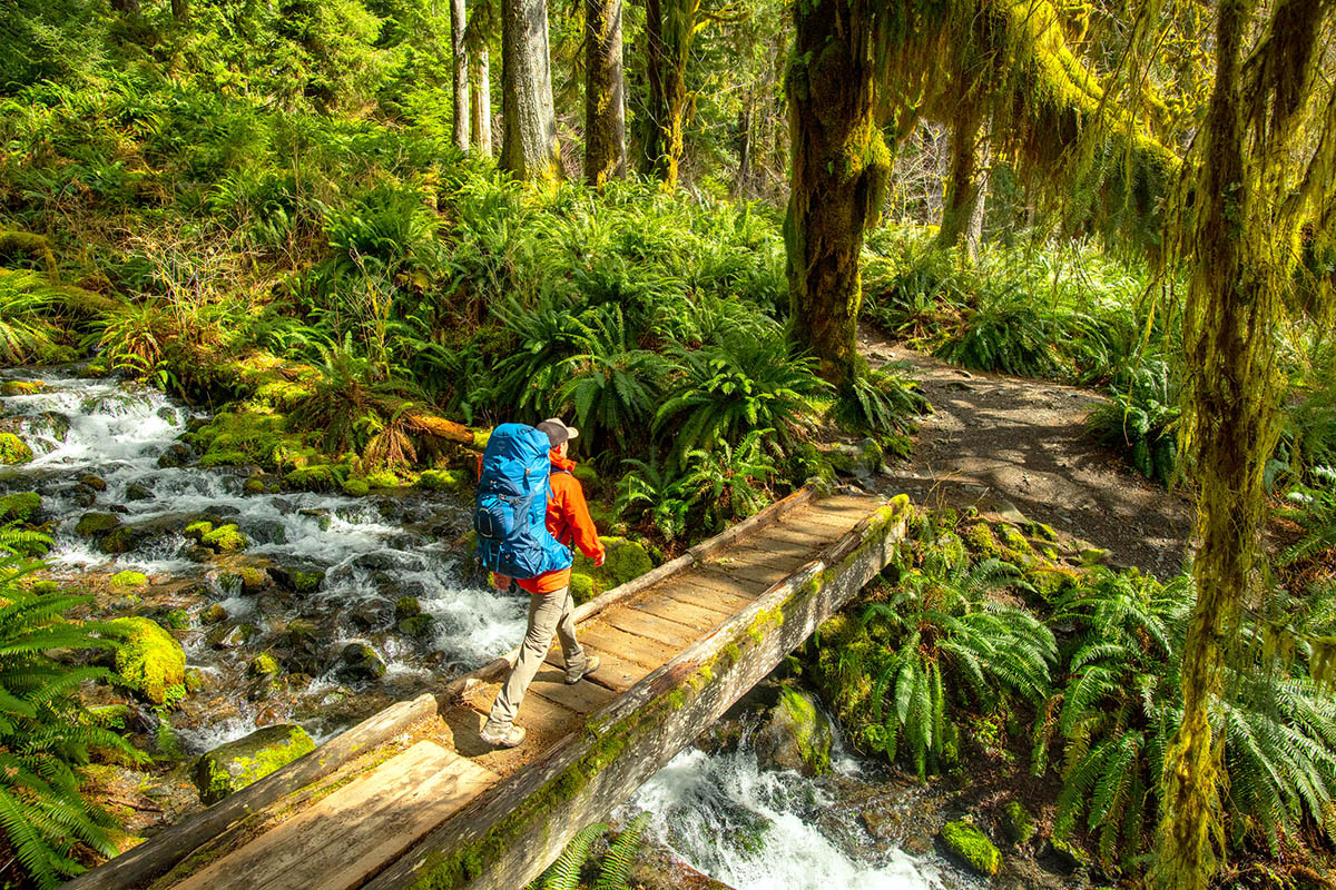


If you love the great outdoors and the sound of water cascading over rocks, you’re in for a treat! Michigan is home to some of the most beautiful waterfalls in the United States, especially in the Upper Peninsula. These waterfalls are perfect for seasoned hikers seeking adventure or families looking for a picturesque spot to enjoy a picnic together.
In this guide, we’ll take you on a journey to discover the 10 best waterfalls in Michigan. We’ll cover everything you need to know about visiting these natural wonders, from how to get there and what to expect on the trails, to what I loved about each location. Plus, we’ll provide you with Google Maps links to make your adventure planning even easier.
So, lace up your hiking boots, grab your camera, and get ready to explore the stunning waterfalls that Michigan has to offer. Let’s dive into the best waterfalls in Michigan!
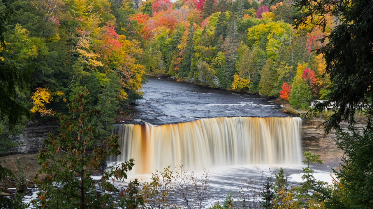
1. Tahquamenon Falls

Waypoint: 46.6440° N, 85.2527° W
These falls are located in the eastern part of the Upper Peninsula, and are some of the most famous and largest waterfalls in Michigan. The waterfall is actually split into two sections: the Upper Falls and the Lower Falls. The Upper Falls are about 200 feet across and drop nearly 50 feet, making them an impressive sight. The Lower Falls consist of a series of five smaller falls cascading around an island.
The sheer size and beauty of the Upper Falls really impresses me every time I visit! I recommend you take the short, easy hike to the viewing platform for the best views. For a closer look, you can also rent a rowboat or a kayak to explore the Lower Falls up close. There are so many things to do in Tahquamon Falls, you’ll be amazed! The trails are well-maintained, and there’s plenty of parking available. The area can get crowded during peak seasons, but this one is not to be missed!
Parking and Hiking: There is ample parking near both the Upper and Lower Falls. The hike to the Upper Falls is about 0.4 miles and is accessible, with a paved path leading to the main viewing area. The trail to the Lower Falls is slightly longer, at around 0.6 miles, and can be more rugged, but it’s manageable for most visitors.
How to Get There: From Paradise, Michigan, head west on M-123 for about 12 miles. The entrance to the state park is well-marked, and you’ll find signs directing you to both the Upper and Lower Falls.
Tips:
- Visit both the Upper and Lower Falls for the full experience.
- Rent a Kayak, a canoe or a rowboat from the visitor center- so much fun!
- Bring bug spray is a must here.
2. Munising Falls

Waypoint: 46.4273° N, 86.6194° W
Munising Falls, located within the Pictured Rocks National Lakeshore, is a serene and easily accessible waterfall. The 50-foot waterfall cascades over a sandstone cliff, creating a peaceful and picturesque setting.
I loved the tranquility of the area, and found the short, easy hike to the falls perfect for all ages and fitness levels. The paved path led me through a quiet forest, and I distinctly remember the sound of the waterfall growing louder, building my anticipation. I love this bit! The final view of the falls was absolutely worth it! I also liked how there were informative signs along the path about the area’s geology and history.
Parking and Hiking: There is a parking area near the Munising Falls Visitor Center, which is just a few minutes’ walk from the trailhead. The trail itself is about 0.4 miles round trip and is mostly flat and paved, making it accessible for strollers and wheelchairs..How to Get There: From downtown Munising, head east on Munising Avenue (M-28) for about 1 mile. Turn left onto Washington Street, then follow the signs to the Munising Falls Visitor Center. The trailhead is located just behind the visitor center.
Tips:
- Visit in the spring or early summer when the water flow is at its peak.
- Take some time to explore the visitor center, which has additional information about the Pictured Rocks National Lakeshore.
- Visit in the winter for incredible ice formations!
3. Bond Falls

Waypoint: 46.4083° N, 89.1307° W
Bond Falls, located in the western Upper Peninsula, is one of Michigan’s most picturesque waterfalls because of the large boulders it tumbles over. The 50-foot drop and 100-foot width create a stunning display of cascading water, making it one of my favorites.
The falls were much larger than I thought they would be, and the different viewing platforms provided incredible views of the cascading water. The short walk from the parking lot along the boardwalk was easy and accessible, but there were some steep stairs. I particularly loved the serene atmosphere and the chance to get close to the falls.
Parking and Hiking: There is a large parking area near the trailhead, making it easy to access the falls. The trail is about 0.5 miles round trip and features a wooden boardwalk and several viewing platforms. It’s an easy hike, suitable for visitors of all ages and abilities.
How to Get There: From the town of Paulding, head east on Bond Falls Road for about 3.5 miles. Follow the signs to the parking area, which is well-marked and easy to find.
Tips:
- Visit in the fall to see the vibrant foliage surrounding the falls.
- Wear comfortable shoes, as the boardwalk can be slippery when wet.
- There are handicapped restrooms near the parking lot.
- Bring a picnic – there are plenty of spots to sit and enjoy the view.
4. Miners Falls

Waypoint: 46.4921° N, 86.5470° W
Miners Falls, located within the Pictured Rocks National Lakeshore, is a powerful and stunning waterfall. With a drop of over 50 feet, it cascades down into a deep, rocky gorge, creating a picturesque scene.
When I visited Miners Falls, the hike through the forest was absolutely delightful. The trail was moderate, with some uphill and downhill sections, but the effort was definitely worth it. We could hear the sound of the waterfall as we approached, and the view from the upper platform was incredible! For an even better view, make sure to go down the steep steps to the lower platform – the closer perspective makes the waterfall even more impressive!
Parking and Hiking: There is a parking area near the trailhead, and the hike to the falls is about 1.2 miles round trip. The trail is well-maintained but does have a few steep bits and a flight of steps to reach the lower viewing platform. You’ll be fine if you’re moderately fit.
How to Get There: From Munising, head east on H-58 for about 5 miles. Turn left onto Miners Castle Road and continue for about 4 miles until you reach the parking area for Miners Falls.
Tips:
- Wear sturdy shoes, as the trail can be uneven and the steps to the lower platform can be slippery.
- There are restrooms here near the parking lot, and pets on a leash are welcome.
5. Wagner Falls

Waypoint: 46.3875° N, 86.6456° W
Wagner Falls, near Munising, is one of the prettiest waterfalls in the area and the most accessible. The falls are part of the Wagner Falls Scenic Site and are a really nice addition to any trip to the area.
This is such a nice place to visit because of its easy access to the parking lot and the great wooden boardwalk which leads to the viewing platform above it. The water cascading down a series of rock ledges into a clear pool below is definitely worth a stop, especially if you’re visiting Munising. Just make sure you bring some bug spray, since I got eaten alive!
Parking and Hiking: There is a small parking area near the trailhead, just off M-94. The trail to the falls is about 0.2 miles long and is mostly flat and easy to navigate.
How to Get There: From downtown Munising, head south on M-94 for about 1.5 miles. The parking area and trailhead are clearly marked and easy to find.
Tips:
- There are no bathrooms or water at this spot.
- Pets are welcome, but must be on a leash.
6. Sable Falls

Waypoint: 46.6734° N, 86.0428° W
Sable Falls is in the eastern part of Pictured Rocks National Lakeshore, and is a stunning 75-foot waterfall that cascades over several sandstone cliffs. It’s the perfect spot for a nature hike, especially if you want to see the fall colors at Pictured Rocks falls.
I visited Sable Falls on a trip to Pictured Rocks and was glad I did. The trail to the falls was well-marked and easy to follow. I loved walking through the forest and really enjoyed the lack of crowds. Although the stairs down to the falls is a great workout, there are lots of observation points along the stairs to stop and catch your breath.Parking and Hiking: There is a large parking area here which makes the trail easy to get to. The trail is about 0.6 miles round trip, and although it includes 168 steps down to the falls, it’s manageable unless you have mobility problems. After taking a look at the falls, we continued on the trail to a really pretty beach where Sable Creek meets Lake Superior.
How to Get There: From Grand Marais, head west on H-58 for about 1.5 miles. The parking area for Sable Falls is really easy to find.
Tips:
- There are no restrooms or water fountains here.
- Pets are allowed but must be kept on a leash.
- Wear sturdy shoes for the hike and steps, and bring bug spray.
- Take the trail down to the beach for a peaceful spot to relax and enjoy the convergence of Sable Creek and Lake Superior.
7. Ocqueoc Falls
Waypoint: 45.4091° N, 84.0461° W
Ocqueoc Falls is the largest waterfall in Michigan’s Lower Peninsula and is a unique spot for hiking, swimming, and exploring. The waterfall has a drop of only 5 feet, but its charm and accessibility make it really popular.
Ocqueoc Falls is one of my favorite stops in northern Michigan. The falls are very easy to get to, with a paved path leading right down to the water and I always look forward to wading in the shallow, clean water. The area is family-friendly and great for a quick swim on a hot day. The nearby Bicentennial Pathway also has six miles of hiking, biking and cross-country skiing in the winter with three marked loops. There’s even a campground nearby, and during spawning season you can’t miss the salmon swimming up the river!
Parking and Hiking: There is a paved parking lot near the falls, and you can take the paved walkway down to the first fall which means it’s wheelchair accessible! The trail to the falls is only about 0.3 miles round trip.
How to Get There: From Rogers City, head west on M-68 for about 11 miles. Turn right onto Ocqueoc Falls Highway, and the parking area is well-marked and easy to find.
Tips:
- Bring water shoes for wading in the rocky river.
- Check out the historic Ocqueoc Falls Highway Bridge nearby.
- The Ocqueoc Falls State Forest Campground is a great place to stay if you want to extend your visit.
8. Stepping Stone Falls
Waypoint: 43.0807° N, 83.6466° W
Stepping Stone Falls is a beautiful man-made waterfall located in Flint, Michigan. It is part of the Genesee County Parks system and provides a great spot for family outings, picnics, and outdoor activities.
Visiting Stepping Stone Falls is lots of fun since there is so much to do. The area around the falls is well-maintained with lush lawns, trees, and native plants making it a beautiful place for a picnic. I particularly enjoyed the well-marked trails that led to various overlooks. The falls are even illuminated with multicolored lights at night! It’s a great place for a family outing, with plenty of picnic tables and scenic spots to enjoy a meal. The Flint River Bike Path nearby offers additional trails for walking, jogging, or biking.
Parking and Hiking: There is a paved parking lot near the falls. The paths to the falls are well-maintained and accessible, making it easy for visitors of all ages and abilities. The Flint River Bike Path connects to the falls, which means you can visit on your bike if you’d like.
How to Get There: From I-475, take the exit for Carpenter Road (exit 11). Head east on Carpenter Road to Branch Road, then turn north onto Branch Road to reach the entrance of Stepping Stone Falls.
Tips:
- The park is open daily from 8 AM to sunset after Labor Day, and until 11 PM during the summer season.
- Alcohol isn’t allowed in the park, so leave your bottle of wine at home!
- Fishing is popular in the area, since the lake is full of fish!
- Lots of pic nic tables throughout the park!
9. Laughing Whitefish Falls

Waypoint: 46.3903° N, 87.0175° W
Laughing Whitefish Falls is actually located in a State Park, and is one of Michigan’s most impressive waterfalls. The waterfall cascades through a picturesque gorge, making it a very popular spot.
I loved these falls, but I guess I love them all really! The hike to the falls was an easy and enjoyable half-mile walk through a beech-maple forest. The trail leads to three observation platforms at different levels, offering fantastic views of the falls. The stairs down to the lower platform is a workout on the way up, but the view from the bottom was absolutely worth it.
Parking and Hiking: There isn’t that much parking here, so arriving early is the best way to make sure you get a spot. The hike to the falls is about 1 mile round trip, with 157 stairs leading down to the lower observation platform. If you have any knee issues, you can always just stick to the upper platform which doesn’t have any stairs.
How to Get There: From Marquette, take M-94 east for about 25 miles to Sundell Road. Turn left onto Sundell Road and follow the signs to the park.
Tips:
- There is a charcoal grill and hand pump for water near the parking area,so you can have a great picnic barbecue here. There are no trash cans though, so make sure to carry out what you carry in.
- Pets are allowed but must be kept on a leash.
- Visit in the spring or after heavy rainfall for the best water flow.
10. Spray Falls
Waypoint: 46.6451° N, 86.1592° W
Spray Falls is an impressive 70-foot waterfall that plunges directly into Lake Superior. This stunning sight is part of the Pictured Rocks National Lakeshore and is best viewed from the water.
I hiked when I visited Spray Falls, since we also visited neighbouring Chapel Falls, but the best way to see it is by taking the Pictured Rocks boat cruise, which include Spray Falls. The view of the waterfall cascading into Lake Superior is quite something. The trail we took started from the Little Beaver Lake Trailhead and was about 4 miles each way. The hike offers beautiful views of the lake and surrounding forests, but we did find it a bit challenging.
Parking and Hiking: There is parking available at the Little Beaver Lake Trailhead. The hike to the falls is approximately 8 miles round trip and follows the North Country Trail along the shores of Lake Superior.
How to Get There: From Munising, take H-58 east to Little Beaver Lake Road. Follow the road to the trailhead parking area. Alternatively, book a Pictured Rocks boat tour from Munising that includes Spray Falls.
Tips:
- Bring plenty of water and wear sturdy hiking shoes if you plan to hike.
- The boat tour is the easiest way to see the falls and offers the best views at sunset.
- There is limited cell service in the area.
What is Michigan’s biggest waterfall?

Michigan’s biggest waterfall is Tahquamenon Falls in the Upper Peninsula. The Upper Falls drop nearly 50 feet and stretch about 200 feet wide, making it a breathtaking sight. This spot is perfect for a great day trip, with plenty of trails, activities and scenic views to enjoy.
How many waterfalls are in the state of Michigan?

Michigan is home to over 300 waterfalls, mostly found in the Upper Peninsula. Each waterfall has its own unique charm, from small cascades to impressive drops. Exploring these falls can lead to some of the most beautiful and serene spots in the state.
Why are there so many waterfalls in the Upper Peninsula of Michigan?
The Upper Peninsula is a waterfall paradise thanks to its rugged terrain and numerous rivers and streams. The ancient rocks and significant elevation changes create perfect conditions for waterfalls. This combination makes the region a hotspot for waterfall enthusiasts and nature lovers alike